Thursday, 18 October 2012

Community archaeologist has gone – long live community archaeology!?

It is somewhat ironic that the surge in job placements in archaeology in community archaeology is a simultaneous development with the disappearance of the dedicated community archaeologist post in Leicestershire. Throughout the eighties, nineties and noughties Leicestershire county council gave support to local groups so that local communities could come together and study the past of their villages. Community archaeologist gave training to volunteers, paid visits to different groups in order to check the finds and teach the members to recognize different materials and provided materials in order to record and storage the finds. These were deposited to the local museum for safekeeping.

Community archaeology has not completely disappeared from Leicestershire but the remit has been joined with the other duties of the county council’s museum service archaeologist. With the new round of savings coming and such measures discussed as the ‘temporary’ closure of the Market Harborough Museum, it is questionable how the new archaeology officer has time apart from an occasional visit to see one of the larger and more active excavating groups in action or help with the deposition of the most important finds together with some general communication duties. After all, the new officer is also responsible for all the collections that are presented in different museums from Snipston to Charnwood and Market Harborough to Melton Mowbray. One person cannot do all – and there is the Festival of Archaeology coming up every year, too!

Nevertheless, the local community archaeology and fieldworking groups have a first class asset in Leicestershire Fieldworkers. Nor has Peter Liddle left archaeology, but he works as a freelancer. The severance of the permanent link with the county council and the financial benefit it brought means that the ways of communication between fieldworkers are changing towards e-mail and internet-based interaction, whereas previously the newsletter was posted to every member. This new situation also means that the groups have to take greater responsibility over their activities and probably also deal with the cost. The Fieldworkers as an organisation guarantees – at least as long the current chairman and Peter Liddle are active – the support the groups need and a way to provide professional assistance to the groups in order to guarantee that the high-quality work continues.

Friday, 12 October 2012

The way we live today

After getting an offer on Phil’s Victorian terraced house we have been looking at the properties and visited a series of homes locally, mainly in different local estates. Naturally, coming from abroad, my perception of normal family home is somewhat different from a normal English one since I did live in apartments all my life in Finland. A flat with a living room, a kitchen and a couple of bedrooms together with a balcony was what I and my friends called a home. Many people aspired buying a plot of land and ‘building’ their own homes – or purchasing a detached house package from one of the providers – something my brother is doing right now. My dream home was in one of the early 20th century stone town apartment blocks with their high ceilings and Jugend/Art Nouveau features.


Your average new development

In recent weeks I have seen a series of detached or semi-detached houses with a living room and a dining area behind in front of the patio windows. You could not have patio windows in the northern climates where you could only have a proper large window and a door next to it with proper insulation. Then it is upstairs to the three bedrooms and the pokeyish family bathroom. Some of the boxrooms are decent but some have the stairwell eating into the room with all kinds of shelf and cupboard solutions built on top of them. The standard living space seems often small and these houses suddenly have made the Victorian pokiness seem less so.

The newer the estate the smaller the gardens. Some of the plots are ridiculously small, when you consider these houses were meant to be family homes from the beginning. The fences have to be relatively low in order to allow sun properly onto the small plots, so you will get to know your neighbours in these locations. In some estates there is a huge front garden, mostly taken up nowadays by car bays. In one front garden there were two white vans and a normal car. In these cases the front space is in good use, but sometimes you wonder, if a larger proper garden or a larger house could have been a better solution.

Then there are the garages. They are not used as garages anymore but feature freezers, washing machines and extra dressers and cupboards together with all kinds of clutter. The modern houses are clearly too small, when the things we really need do not fit in into their small kitchens. Some of the dining areas can hardly fit a table for six and can feel claustrophobic, if the large patio doors lead to a very small garden. All the light but no space.

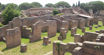
This economic use of space is nothing new. Already the Romans were building type houses and blocks and flats with repeated floor plans. The ancient Ostia has plenty of these buildings that can be explored by modern visitors. These rooms seem to have been relatively dark, although this is sometimes difficult to clarify due to the partial preservation of the remains. The large villas and town houses were lavish and spacious, but the flats could be very pokey. Money talks – and did talk.

Thursday, 4 October 2012

Coins in a context

The Hallaton treasure gives us an unparallel insight into the deposition of coin hoards, even if it presents a special case with the late Iron Age shrine it is connected with. Vicki Score (2011) and a series of specialists have published lately a full volume to present different aspects of the hoard. Even if it is clear that more cartographic presentations and reconstructions will follow taken the emphasis on textual representation in presenting the context and interpretations, the volume shows us how the coins entered into the treasure.


Iron Age coins from Hallaton Treasure

Approximately 64 % of the coins originated from properly excavated stratified contexts. Out of over 5000 coins only 149 were Roman and 116 from other Iron Age areas outside north-east Corieltavi. Most stratified finds were related to an entranceway or to the Roman helmet. The latest Roman coins struck were from early Imperial period from the reign of Emperor Claudius AD 41/42. This confirms the exceptional nature of these deposits originating from a time when ‘the Romans were coming’.

The excavators could count 14 separate hoards in the entranceway area, several of them in clustered appearance, clearly been put into ground in ‘purses’. The make-up was very similar and the coins came from the same circulation pool. They were deposited over an extended period but Leins in the volume assumes they were buried in c. AD 43-50, during the early post-conquest period when the East Midlands was falling under the Romans. The coins buried with the helmet, presenting two different areas of deposition, nevertheless seem to form a single act of deposition. There was a discreet group of coins in the north-eastern part of the helmet pit but there was a number of coins alongside the helmet. The chronological distribution of the helmet coins was consistent with the reign of Emperor Tiberius.

In comparison, only a tiny number of coins came from ditches or other contexts. However, the composition of the ditch contexts was different with 50 % of coins being unstruck early types. These coins represented only a few percent of the entranceway or helmet deposits. There were other metal objects from the ditch, including a silver bowl and silver and silver and copper alloy ingots. The ditch deposits were partly destroyed by a land drain so a detailed reconstruction of the ditch fill contents is not possible.

The general trends in chronological composition were very similar, if not identical to the Scole and Warmington hoards. However, the Hallaton distribution peaks at 89-80 BC that is considered peculiar to the site. A number of coins from the stratified contexts and especially from unstratified ploughsoil are from later Roman periods. There were coins from the Flavian period and the reigns of Trajan and Hadrian but a higher number from the late Roman times, especially the late 4th century AD. These finds seem to avoid the Iron Age ritual area, though.


The Hallaton promontory hillock overlooking the rivervalley

The coin deposits follow different logics. The early ditch deposits were lying on the left-hand side when going in, whereas the entranceway deposits were on the left-hand side when going out. In addition, the feasting deposits were buried outside the boundary. Score suggests a social distinction between the participants inside and outside. The location of many of the hoardsites near the hilltops suggest that the rituals were highly visible to those who were not directly participating in the acts.


Score, V., 2011. Hoards, Hounds and Helmets. A conquest-period ritual site at Hallaton, Leicestershire. Leicester Archaeology Monograph 21.

Thursday, 27 September 2012

Beaumont Leys, a suburb already in the Iron Age?

One of the most interesting things archaeologically about the Beaumont Leys estate is not necessarily how it stands for the modern architectural ideals that went slightly sour, but how it is a site of ‘aggregated’ Iron Age settlements. No isolated farmsteads here, but a sinuous linear boundary and north from it the remains of nine or so roundhouses, some of them comfortably c. 10 m in diameter.


The sites at Beaumont Leys (© Leicester City Council and MapInfo)

There were signs of earlier visits during the Neolithic and Bronze Age in the form of occasional sherds deposited in otherwise Iron Age structures. This site is one of the hut sites at Beaumont Leys presented in the City Council MapInfo Historic Environmental Record (HER). This is not even the only area with a site of this type but there is another one, excavated around the same time in Humberstone and published in the same volume (Thomas 2011). Nevertheless, visiting Beaumont Leys every week and normally just seeing the shopping centre or the petrol station makes it delightful to know that there is more to the reputation of this estate.


Linear feature on Google Maps

Now the main archaeological site is the site of an Office depot and your average industrial estate warehouse building with a huge car park, virtually approachable in Google Street View. The astonishing fact is that in Google Maps the excavation is still visible and you can follow with your own eyes the linear boundary (see above) rounding up the site on the southern site. In your mind’s eye you can almost see ‘Asterix’ and ‘Obelix’ walking into the roundhouse of the village druid while keeping the troubadour at an arm's length.


Game model of the Gaulish village (linked image from Eclypsia game pages)


Thomas, J., 2011. Two Iron Age 'Aggregated' Settlements in the environs of Leicester. Excavations at Beaumont Leys and Humberstone. Leicester Archaeology Monographs 19.

Thursday, 20 September 2012

Darkness in the sun


Jersey beach

There is one part of the UK that was under Nazi occupation. The Channel Islands along the French Coast were occupied for almost five years between 1940 and 1945. The beautiful beaches in Jersey are dotted with watch towers, and the public can visit bunkers and tunnels at different locations on the island. The other islands have similar monuments but for family reasons I keep visiting Jersey.

The island provides wide sandy beaches with dunes and moorland. On a fair day the sea is blue and turquoise, and you have the vineyards and agricultural land inland with cattle herds and endless rows of potato. For a long time the occupation heritage was not discussed much but lately there has been a lot of activity in order to gather more information from the dwindling population who can still remember those times and to make people aware of the past.

The Channel Islands Occupation Society has looked after the building works since the 1960s but a Cambridge researcher with Guernsey roots has been studying the different aspects of the Occupation legacy and its materiality lately. Dr Gillian Carr has four current research projects, running or about to start, devoted to the archaeological evidence from this period. Her first project discusses the heritage of the Second World War and the German Occupation on the islands, whereas the second project looks at the material culture of the prisoners of war during that period. The third project explores the more comfortable aspects of the occupation, namely protest and resistance against the occupiers. Her fourth project will be on the archaeology and heritage of forced and slave labour as part of a European research project related to the Atlantic Wall.

This research activity and the related exhibitions, conferences and seminars allow revisiting this dark period at a moment, when enough time has passed for the collection of its memories to become urgent but also more palatable. The monuments around Jersey always tell a walker about the heritage of the island. However, the megaliths of Jersey remind of a more positive distant past that does not require reminding people about past deportations and other horrors.

Thursday, 13 September 2012

Landscape of car parks

Serious heritage ‘outlets’, historic houses and famous sites, do not only have to present their famous contents but also cater for the needs of the visitors. A large majority of sites are not conveniently by the centre of a town as the Ashby Castle is. The English Heritage parking area is minuscule and intended for disabled visitors. The visitors use the general parking areas in this market town.


Chatsworth car park (image: Google)

The largest of sites have huge marked parking areas and extensive facilities to provide food and shopping opportunities, not only for the convenience of the visitors but also in order to raise revenue for the sites. One of the huge professional operations is Chatsworth in Derbyshire. The recent BBC series hints the huge extent of the facilities but only a visit to the buzzing gardens and a look at the Google Earth imagery shows that the car parks – even if covered partly by trees at spacious intervals – cover an area larger than the house itself and its rose garden.

I must be in a minority in not opposing to the roads by Stonehenge. But then the fame of Stonehenge had created this immense mental perception that was duly trashed when the public bus was approaching this destination. The famous site looked much smaller than the extent it had grown in my mind. Nevertheless, people have needed to cross this landscape for ages and the roads have been there for a long time. I can understand that it improves the asset of Stonehenge to try to strip the immediate landscape of these ‘modern’ layers and allow admiring the viewlines, but at the time I was thinking that the earlier plan to dig a tunnel to save a short stretch of a sight of a road was not really realistic. No matter how marvellous opportunity that plan would have given to archaeologists who would have had to excavate along the tunnel line and could have made extensive scientific studies of soils and paleoenvironment. You could hear the brains of the paleoarchaeologists to make plans.

Cars are part of our current culture and the heritage sites have to be managed. Thus, the car parks are here to stay and if they are not next to the site, they will be somewhere nearby, even if out of sight.

Wednesday, 5 September 2012

Looking for a bad king

Shakespeare and in a much lesser part Josephine Tey have a lot to answer for in creating the modern perception of king Richard III. The king famously perished in the battle of Bosworth (also mentioned in this blog), in 1485 while in Shakespeare’s play (Richard III, Act 5, scene 4, 7) he uttered the famous words “A horse, a horse, my kingdom for a horse!”. After his death he was taken back to Leicester to a Franciscan Friary in the city.

Now a University of Leicester archaeological team is digging in the city's Greyfriars car park where they think he may have been buried. The precise location of the burial has been long lost but with the modern methods they hope to pinpoint the right location. The project team says that their work is “the first ever search for the lost grave of an anointed King of England”.

This was headline archaeological news presented with some Bosworth re-enactors giving a play battle in the car park. Richard Buckley, the co-director of the University of Leicester Archaeological Services, revealed the real archaeological aim behind the news-grabbing quotes. The main thing is to find the foundations of the Greyfriars church and place it in the matrix of the Medieval town.


The trial trench (photo: University of Leicester)

A ground-penetrating radar was looking for the lines of the foundations in the car part and now the team has two weeks to reveal any structures. So far they seem to have found what they were looking for - the church, not the body, yet. However, one element of the project has to be pointed out. Somebody had been ploughing through the archives and tracked down a full female line of the descendants of Richard III. A male descendant had been found, and on cameras he took a swap in order to give a DNA sample for the team. However, nobody praised the traditional historical ancestry research, which was required for any more modern analyses.