Thursday, 8 March 2012

Knights Templar among us

Knights Templar, even if a real order founded during the Crusades, seem to belong to the murky conspiratory make-believe world around the edges of the scholarly and religious circles depicted in the novels of Umberto Eco and Dan Brown. However, the templars were among us during the Medieval period and had granges in many parts of England.

What I thought to be our nearest hill fort, Castle Hill at Beaumont Leys, is not a hill fort but a rectangular enclosure, earthworks that that belonged to a Preceptory, a monastery house of the Knights Templars. Locally the humps and bumps are considered Iron Age but when we finally visited the country park were the site lies I was puzzled by the rectangular form and with some later earthworks and different brick structures.

When back home I checked the City Council’s Scheduled Monuments list and the ADS archsearch over the Internet and found out about the true nature of the earthworks. Sadly, during the 19th century the area was used for sewerage purposes by the City of Leicester and this use damaged the preserved monuments. Already in the Medieval times the site had passed to Knights Hospitallers after the Knights Templar were dissolved. The Hospitallers exchanged the site in 1482 with the King and received the Rectory of Boston in this transaction. Soon afterwards the site fell into disuse and was for a long time pasture before the sewerage, evidenced by the brick structures.

The site has never been excavated but the University of Leicester has mapped the area. The archaeological map of the City shows that apart from the Medieval site the area has revealed a possible Roman field system and Neolithic and Bronze Age find concentration. There are also Roman and Medieval pottery finds from the area south and west from the rectangular enclosure. The site of the Preceptory has a dominant position and there is intervisibility with the Old John hill. The Brook passing the area between Anstey and Cropston on one side and Beaumont Leys on the other is not the worthy of the Soar itself but it is still a natural devide. The brook facilitated the use of the area as a sheep farm by the Knights Templar, as has been suggested. Nothing conspiratory in that land use – the revenues were needed in the operations in the Holy Land. Castle Hill was just one of many similar money-making sites for the Knights in the East Midlands (see Lewis 2006: 214).


Lewis, C., 2006. ‘The Medieval period (800-1500)’, in N. Cooper (ed.), The Archaeology of the East Midlands: An Archaeological Resource Assessment and Research Agenda, Leicester Archaeology Monographs.
Note: The Archaeological map of City of Leicester works best with IE.

Thursday, 1 March 2012

Messages from a workhouse

I visited lately a former workhouse outside Gressenhall in Norfolk, now a museum of rural life and Victorian and later periods. The Victorian systems of supporting poor were different in different parts of Europe but in England the children and adults who could not provide for themselves were placed in workhouses. The system was only abolished with the foundation of the NHS after the Second World War and the last pieces of legistlation were changed in the late 1960s. The discussion around the unemployed and disabled has recently taken a turn towards a more sinister direction and the word ‘workhouse’ has been uttered by the critiques of the schemes where a young job seeker has to take a ‘work experience’ placement stacking supermarket or pound shop shelves or flipping hamburgers for major national and international firms. Thus, it was interesting to see how a real workhouse looked like.

The location was in the middle of the deepest Norfolk without any proper modern public transport connections. A large red-bricked building stood in a relative isolation. A workhouse was a product of the 1834 New Poor Law that replaced the Old Poor Law of 1601. The latter had been a network of ad hoc solutions created and governed locally at the parish level whereas the centralized system of workhouses embodied the idea of the poor as somehow morally lacking and responsible for their lot from which they could lift themselves if they wanted. The New Poor Law stated that for able-bodied persons or their families –
in fact for everybody else than the very sick and those in certain other exceptional, well-defined circumstances – all help and upkeep was declared unlawful outside well-regulated workhouses, places where they were put to work towards their subsistence.

Workhouses were set up already before the New Poor Law, most often by the parishes. However, with the new law they became compulsory and replaced the Christian-spirited duty of taking care of the vulnerable in the local community. The Poor Law Commission created Poor Law Unions in order to pool parishes together and create larger units at the local level to support workhouses. Our local workhouse was in Barrow-Upon-Soar but its buildings have mainly disappeared. Only one part of the complex is still standing and it has been transformed into a private residence. The workhouse itself served a long time as a hospital, which it has common with many other establishments, for example in Bradford in Yorkshire, where the old people allegedly did not want to go to the hospital because of this part connection.

The large building in Norfolk looks like any institution built during the Victorian period. It looks like a factory or a prison. However, workhouses were entered voluntarily when the circumstances of an individual became too difficult. The usual workhousers included the unemployed, disowned unmarried mothers, orphans, old and sick and mentally ill. Thus, the building and its location confined the poor and morally suspicious to be interned outside the main community. Foucault did call the English workhouse the English form of the ‘Great Internment’ when he discussed the subject briefly in the History of Madness; he probably kept it short since the workhouse was not primarily a mental hospital. His argument that power does not depend not on material relations or authority but primarily on discursive networks seems to fit the workhouse. The workhouses were an answer to a social problem, centrally run, widely criticized but even exploited by some poor for their own benefit. As a phenomenon it reflected the moral values and the organisational needs and pursuit of the majority in its time. Our example at Gressenhall as a building at least spatially delivered the centralized message and showed the poor their marginalized place.


History of English workhouses, see The Workhouse web site.
Workhouse and Foucault, see the Foucault blog.

Thursday, 23 February 2012

Landscape of an object

The surface of an artefact is a landscape to be studied in the same way as a terrain in the real world. Objects have been scanned and studied microscopically for some time now and the scanning electron microscopes (SEM) used to study the edges and use wear of flint and other stone tools are used also to study other types of marks and details left by manufacturing, decoration and use. The resulting images allow studying the traces of the tools used in manufacturing or showing interaction between different materials. The grooves and polishes of the surfaces can be viewed as surface models in the same way as LiDAR images are the digital representations of real landscapes.

The photo provided by galileo.com

Not many people outside the discipline of classical archaeology – or more precisely Italian or Roman archaeology – know the story of the Fibula Prenestina. This delicate golden brooch was presented by the famous German archaeologist Wolfgang Helbig in 1886 in the German Archaeological Institute in Rome as carrying the oldest Latin inscription (MANIOS:MED:FHE:FHAKED:NUMASIOI, Manios has made me [or, had me made] for Numasios) on its catch. There were some muted murmurs since the exact circumstances of the find were not known and it was just alleged to have been found in Praeneste, an ancient Latin town and a finding place of two of the richest Orientalizing tombs of pre-Roman period dating to the 7th century BC. Many people have assumed that it possibly originated from one of these, the Bernardini tomb. This so-called princely tomb had been excavated in 1876. The details of the find were reported only later and the detailed catalogue of all grave-goods does not exist. The unknown provenance makes it difficult to evaluate the genuinity of the object and the alleged earliest inscription.

The photo provided by galileo.com

An Italian scholar Margherita Guarducci studied the object in detail in 1980 and concluded that the inscription was poorly executed and the surface had been treated with acid. The gold was also different from the one in the real brooches from Praeneste. These findings and the resulting arguments became the source of a long-standing controversy. However, now the microscopic study has been said to have proven without doubt that this brooch is a genuine article. Last year a round table presented the new results from a detailed study. The surface of the object had been cleaned during some clumsy restoration and conservation operations but there were also signs of ancient repairs with thin layers of different gold placed on the surface. Physicist Daniella Ferro from the National Research Institute (CNR) told press that the inscription had been inscribed in the similar manner as the decorations on the brooch and that the technique was unlikely to have been mastered by a faker in the late 19th century when the knowledge of the brooches was still scarce. In this case it is known that the specimen was provided by a dealer and a faker, named Martinetti, a fact Helbig had tried to hide.

The sad truth is that even if the brooch clearly stems from the period, the genuinity of the inscription can always be considered uncertain because the lack of provenance. If it was not a loose find passed down by the dealers but an object discovered during the excavations, these long discussions and doubts would not exist. Archaeological finds lacking their context and requiring the observation of the landscape of their surface and the testing of their materials leave always the ultimate answer with a tiny amount of doubt. The proof in this case also has to include the undoubted proof that no faker could imitate at the time the ancient techniques used in manufacturing the few then known fibule.


See also:
Maras, D. M., 2012. ‘Scientists declare the Fibula Prenestina and its inscription to be genuine “beyond any reasonable doubt"’, Etruscan News, 14, Winter 2012 on academia.edu

Thursday, 16 February 2012

Chronologies and landscapes

I am currently writing an article for which I have looked for the application of the suggested calibrated carbon date chronology for the central Italian later prehistory. Originally, there was controversy about this scheme based for the Final Bronze Age and Early Iron Age on the dates from south of the Tiber in Latium Vetus (see Nijboer et al., 2002). Due to the analogical use of period names in Etruria and the similarity of the material culture these new periods should also be used north of the Tiber and this seemed to raise opposition. This discussion was ongoing when I did my PhD and now I am returning to the subject.

The difference of chronologies is important since the new datings shorten the Final Bronze Age and extend the length of the Early Iron Age. The former is cut from 300 years to 200 years in maximum and the same amount of time is added to the latter. This would give more time for the emergence and expansion of the large Etruscan towns on the coast and less time for the blooming and restructuration of the ‘Proto-Villanovans’.

I had heard mentioned that the opposition for the new calibrated chronology may have somewhat died out but as I have noticed while assessing the situation, there are still problems with the absolute datings. I noticed that Bietti Sestieri’s and De Santis’ (2007) article – with the new calibrated chronology – was recently the only one on the period in an Italian prehistoric conference. However, it discussed the changes during the Iron Age more than chronology and thus I will still have to read the volume edited by Bartoloni and Delpino (2005) carefully, especially since the disparity between the periodization and absolute dates of some phases of the Early Iron Age in Bietti Sestieri’s and De Santis’ (2007) paper raised my eyebrows. In addition Bartoloni and Nizzo (2005) did not seem to be impressed by the new high chronology.

When reading and using the newish volume on the Final Bronze Age settlements in southern Etruria (Barbaro 2010), I noticed that this volume did not discuss any absolute dates in length. It strictly confines itself to the use of different sub-periods (BF1-2, BF3A1, BF3A2, BF3B). The diagnostic features of the material culture, or more fittingly those of the decorative schemes, were divided between the sub-periods and the settlement sites of the period were classified and periodised accordingly suggesting which sites were settled during which sub-period. This was all fascinating and useful but left the periods of times these sites were truly or tentatively settled unanswered. The question of how lomg and which sites were settled simultaneously is complicated.

Bibliography

Bartoloni, G. & Delpino, F. 2005. Oriente e Occidente: metodi e discipline a confronto. Riflessioni sulla cronologia dell'età del ferro in Italia, Atti dell'Incontro di studi, Roma, 30-31 ottobre 2003. Mediterranea 1.

Bartoloni, G. & Nizzo V. 2005 at academia.edu

Bietti Sestieri, A.-M., & De Santis, A. 2007. ‘Il Lazio antico fra tarda Età del Bronzo e Prima Età del Ferro: gli sviluppi nell’organizzazione politico-territoriale in relazione con il processo di formazione urbana’, Atti della XL riunione scientifica: strategie di insediamento fra Lazio e Campania in età preistorica e protostorica, Roma, Napoli, Pompei, 30 novembre-3 dicembre 2005, dedicati ad Amilcare Bietti, 205-230.

Nijboer, A.J., van der Plicht, J., Bietti Sestieri, A.M. & de Santis, A. 2002 'A high chronology for the Early Iron Age in central Italy’, adapted from Palaeohistoria 41/42, 1999 at the University of Groningen web site

Thursday, 9 February 2012

Landscape under snow

A couple of my friends posted photos onto Facebook after this weekend’s snowfall in Rome. The newspapers printed pictures of Colosseum under snow – with some brave Italians driving on the main road curving by it. However, the Italians are well used to snow since many people living in Rome are from small towns on a higher ground in central Italy where snow is an annual visitor and the roads are steep and windy. Rome lies much lower nearer the sea so the snow on the uplands dow not reach urbs.

Photo by Ettore Ferrari/EPA

People – or hominids – have to have been able to deal with the snow for thousands and hundreds of thousands of years. We know from the Ötzi find that by the Bronze Age people customarily crossed the Alps and were able to dress appropriately for the conditions. They must have done this a way back since otherwise the expansion of the humans into the northern areas of the globe after the Ice Age would have been impossible. Winter weather must have existed and those mammoths needed hunting all year round. The preservation of non-organic materials only means that our perception of the Stone Age is primitive and we do not see the full skill set of ‘the Eskimos’ of the earlier time. Even the Neanderthals buried their dead so it is likely they were capable of inventing or using a bone needle and gut string.

Now whole England grinds to halt with a snowfall of 5 cm of snow. In the past the wintertime was hindering the movement of those with no means of getting proper clothing or lacking with skies or sledges and animals or humans to pull them. For appropriately geared individuals and groups moving across a landscape covered in snow is not too much of an effort. Ice cover joins large areas with each other along the coasts and it allows ice hole fishing and seal hunting around the breathing holes.

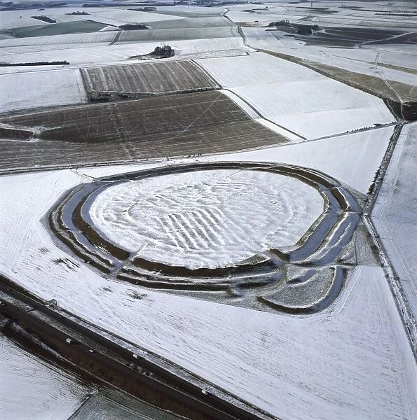
The past wintertime is mostly invisible in archaeological record and only accessible indirectly since the ice finds such as the Ötzi are not as common as for example the bog finds. It is easy to point out the cold years from the environmental record and the ice cores allow a direct access to snow volumes at certain points. In the north much of the food storage must have been meant for the wintertime and the huts and houses were essential. When we see photos of the landscapes of the famous hillforts covered in snow we get a glimpse of the winters past in the present.

Thursday, 2 February 2012

Google Earth to archaeology

Stonehenge and handful of other famous archaeological sites such as the Pyramids serve often as a testing ground for new computer methods and prospecting tools. This is because of their easy recognisability among the non-archaeologists and the awe these structures raise. Now the Stonehenge Riverside Project has extended its accessibility to the Google Earth and iPhone. This has been achieved in collaboration with the Google Research Awards, a program with which Google tries to create relationships between the firm and the academia as part of its ambitions related to information and its accessiblity.

‘Google Under-the-Earth’ is an extension of the Google Earth; with it you can add archaeological layers to the base terrain provided by the tool. The data excavated and gathered by the Universities of Sheffield, Manchester, Bristol, Southampton and London has been used to develop ‘Seeing beneath Stonehenge’. The layers allow access images, geophysical data, site plans and video. The selection also includes reconstructions, such as the timber monument of the Southern Circle.

Stonehenge Google view by the Bournemouth University

This type of beneficial relationships are nothing new and the same kind of pilot projects were created and made publically known when geophysics and computer modelling were in their infancy and the large corporations developing the technologies needed to show that the products had several different kinds of uses in the real world. However, it is without doubt that this project in particular increases the knowledge of the wider public of the results of the Stonehenge Riverside Project. One does not have to travel anywhere in order to study the results and the presentations in detail.

Naturally, the developers at Bournemouth University hope that other great archaeological sites could be incorporated in this way and Google Under-the-Earth could display some of the archaeological [digital] excavation data from the great archaeological sites collected during the last twenty years. However, this will require funds and it will be seen if these continue to be distributed by the Google Research Awards now when the world-famous pilot is out and done and dusted. I am sure the archaeologists are eager to participate but the creation of materials will require the main stakeholders at different sites and different excavation areas collaborating and somebody to do a lot of preparations and work. I also hope that the copyright issues have been thoroughly discussed.

Similar pilot involving Stonehenge is the ‘Stonehenge Experience’, an iPhone App developed by the University of Huddersfield and the web developers Ribui. Now one can see the reconstructed Stonehenge on their phone. It seems the Stonehenge is the most modelled site of them all and unlike much of the world heritage can be seen over most of the platforms - also by your avatar. yes, and I remember sitting through a number of virtual Stonehenge presentations already ten years ago. One can only hope that the funds can stretch to include more data from other sites into these systems – and not only through free labour.

Thursday, 26 January 2012

Everyday landscape

No matter how lovely the view or beautiful the streetscape when one goes about one’s normal business the places and landscapes do not feel so lovely as they do the first time one lies one’s eye on them. I have been lucky enough to live on top of Gianicolo, the high hill on the Vatican side of the Tiber in a 16th century villa with all Rome at my feet. Did I look across Rome on most of the days? No, I did not. I just holed in the library.

I lived for years in Cambridge and on most of the days I did not bat an eyelid on my way to buy a sandwich at the University or crossing the river Cam in order to reach the Classics library or the University library. I may have noticed the crocuses or the bluebells in the Backs on a sunny spring day or paused to look at the swan near the King’s. However, even today when I run to the bus stop from the University Library, I hardly marvel the buildings of Trinity or the Gate of St. John. They just happen to be on my route.

How often do I raise my eyes and look at the beautiful historic buildings in the city centre in Leicester? I must admit that many buildings, such as the St. Margaret bus station, I really could do without seeing. However, the marvellous Turkey Cafe or the former Midland bank on the opposite side of the road with their Moorish or Venetian influences brighten up anybody’s day.

One becomes blind to the beauty of one’s everyday environment and we seem to consider our everyday surroundings mundane. The routes are in the mind’s landscape and even the most beautiful building becomes the background of the everyday routines and rut. If it is overcast, grey, foggy and rainy, even the most beautiful cityscape loses its lustre. Probably Avebury would be a total dump if one had to work from 9 to 5 at a rescue excavation in the icy February rain. If you are covered in mud and your feet are wet, the last thing you want to do is to consider the aesthetic value of a stone circle.