Thursday, 4 July 2013

RIP Mick Aston

After moving house and finally getting the broadband reconnected, I managed to update my blog. During my enforced break from blogging among the sea of cardboard boxes some archaeological news have reached us. On one hand the University of Leicester is to continue the study of the Greyfriars in order to study some other graves under the car park and on the other a Durham student has found a head of a statue from a Roman shrine. However, the biggest news during the last two weeks has been the demise of Mick Aston.


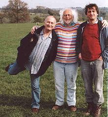
Mick Aston (centre) with his Time Team colleagues

I did meet Mick Aston personally several times at Bristol when I was studying for my MA in Landscape Archaeology. When I arrived to England, I was totally ignorant of Time Team, since it had not travelled to the Continent, yet. I was wondering the knowledge of geophysics my fellow English students seemed to have. I only understood after viewing the programme.

Since I did not take part into Time Team, I only met Mick in some departmental functions and trips that were part of my taught course. We visited the Shapwick village, the site of the project Mick ran for decades, where he personally explained the history of the project and the resulting depth of knowledge of that village.

He was a gentle man, liked by the PhD students who helped him in his media research. His wild hair and colourful jumpers seemed to be part of his role, but also implicated his jovial and relaxed nature, which was not some added 'pepper'. We all witnessed how Time Time slowly withered away. It was a pity his last year was filled with some controversy and ill health. However, his legacy in British landscape archaeology will live on.


If you have not read Mick Aston's famous text books, Landscape Archaeology: An Introduction to Fieldwork Techniques on Post-Roman Landscapes (with Trevor Rowley) from 1974 and Interpreting the Landscape: Landscape Archaeology in Local Studies from 1985, you can introduce yourself to his speciality by reading this short treatise on the Medieval landscape in Somerset.

Thursday, 13 June 2013

Early experiences from running an online course

The greatest surprise this far when running my Googling the Earth online course is the amount of 'proofreading' it requires. In the end it is not enough that you come up with an idea, sell it, prepare the material and hand it over. One also has to make sure that it is correct, since the lovely people in the e-learning department do not know the subject matter. In the end, the person who has created the material knows the order it has to be presented for a maximum learning effect and how different parts (podcast, audio PowerPoint, web pages, exercises and links) link and build up into a learning experience.

I have realised that I have probably included too much content into the course. This is quite normal for an academic archaeologist; you just think the amount of basics people have to grasp in order to be able to process certain new topics. However, the learners probably do not have too many hours per week for studying, so I hope I have not prepared too much to be ploughed through. On the other hand, one had to prepare for a situation where you have a novice in landscape archaeology who wants to use different online resources and give them enough of the context in order to be able to carry out and understand the exercises.

Designing the exercises was also a little daunting, since some of the course participants are really active in their part-time study or have membership of different fieldworker or archaeology groups. If they are really computersavvy, they can do exercises really quickly. There may also be some topics they consider knowing enough and they skim the content and choose the exercises they have been looking for. This makes it a difficult balancing act.

The most unpleasant thing is checking the sound tracks. I am not used to listen to my own voice and I am sure one picks oneself all those awkward pauses, hesitations and scrambled words to the maximum effect. Luckily, there are the bullet points to read for the students and in places it sounds OK. It is a pity I did not have the instruction book for the audio recorder, so I did not try forwarding or rewinding the tape. Next time I will do more retakes!

Even if we do have a discussion forum, I do not have direct contact with the students when they are doing the exercises. Thus, any sticky points will come out only later – and only if they comment on them. In this type of course they do most of the work themselves. Luckily, they will send me a very short mini project of their work at the end, so I will know if they found it useful and learnt new skills. If so, I will be content.

Thursday, 6 June 2013

Secrets of the Stonehenge skeletons

I finally had an opportunity to see the Stonehenge documentary, repeated on More4 in a comfortable 9 o’clock slot recently. Even if at the core of the programme there were some interesting hypotheses, some better established than the others, some of the attention ended up directed to a series of design choices that clearly were made by the production company and outside the powers of the archaeologists.

We all have probably recently been complaining about the irritating re-enactments in archaeological documentaries. There are the pretend ancient Egyptians in their thick black wigs carrying bowls in dark corners or sitting on replica chairs when intriguing modern classical music is playing. There are the screaming attacking armies of the barbarians, Persians and/or Celts. There are the Iron Age People cooking in their woollen clothes in a dark round house, when the smoke is quietly floating around, while a voiceover keeps repeating the same mysterious lines over and over again. However, this time the budget may have been smaller than normally, since any alive re-enactors were replaced – by shadow puppets. The kind of puppets you see in the south-eastern Asian displays. This was a true novelty.

The documentary also kept repeating the same shot of Mike Parker Pearson walking among the stones of Stonehenge and observantly look up to their top parts. This section reminded me in an unintended manner of the movie Plan 9 from Outer Space. In that movie, voted to have been one of the worst ever made, a section with Bela Lugosi, then already deceased, and some other shots were reused continuously. However, this documentary I was watching naturally was light years better than the movie, but the continuous repetition of the same scenes hints that the programme uses the building up of intrigue techniques that repeat same questions, such as ‘why did the use of Stonehenge stop so abruptly’, before the ad breaks. The continuous repetition also suggest that there was really material for a 45-minute documentary, but the programme had to cover a certain slot. Although there is always more than 45 minutes worth of stories from Stonehenge!

On the positive side, it was crucial to get a neat summary of the findings of the excavations of the Aubrey Holes in this programme. However, some of the arguments were surprising - although the script must have been edited by the production company. The programme makers suggested that before the Riverside project people did not know that the first Stonehenge did not have the stone circle with headstones in the middle. However, Atkinson had already written in his book in the 1950s that the first Stonehenge was a simple henge with a ditch. The important Riverside novelty was the observation that there were probably bluestones instead of wooden poles in the Aubrey Holes. This is a true novelty, but not the same thing as them finding out about the simple first henge for the very first time.

I really appreciated the study of the reburied cremated bones from the Aubrey Holes. That must have felt like a very daunting task at first, but the cleaver use of ear bones as the marker of the number of individuals was impressive. Nevertheless, I am not sure how the presence of burials of both men and women together with children was evidence for the existence of a special religious order at Stonehenge and the members of which were buried there under the first simple stone henge.

Another thing that made the re-excavation of the Aubrey Holes bones remarkable was that every single director of the sub-projects of the Riverside project took turns in carrying out the humble duties of excavating with trowel.

Thursday, 30 May 2013

Central Mediterranean Prehistory Day: from Sardinia to the Balkans

Just when I had started to wonder, if I remembered correctly and if there was a Central Mediterranean day in May, I received an e-mail containing the programme of the research day at Cambridge. I had originally other business on that day, but it was cancelled I could have now given a paper. However, the programme was full, so I could relax and listen what other people had prepared for the day. It was a very interesting day, presenting a few of the new ERC funded projects and a lot of Sardinia.

Even if I am not going to lose my interest in English landscape, the things have taken an unexpected turn in such a way that I will mainly concentrate on central Italy the next academic year. This is not bad, since I have still a lot to prepare for publication and this spring trying to improve my teaching portfolio has taken most of my time – when I have not been finishing money applications or articles to be sent for peer review or to be submitted. At least those hours spent in writing hypothetical research proposals have not gone totally in waste. For 12 months from September I will concentrate on Archaic and colonial geographies. Not that I won’t be following a side project as well on my spare time in order to improve my chances in multidisciplinary discussions...


EUROFARM project web site

The Central Mediterranean Prehistory Day was during the same week as the social media and public archaeology workshop that I wrote about last week. This Mediterranean research day was not without its fair share of computing. EUROFARM project headed by Marc Vander Linden is going to model the early streams of neolithisation along the Mediterranean coast and inland in the Balkans, where these different innovative strands are the nearest in Europe. Craig Alexander, when not working with rock art, will be doing GIS for the archaeometric XRF project in the Neolithic Tavoliere, whereas Francesca Fulminante was presenting her network analyses. PROCON project, directed by Margarita Gleba, will not model as much as many other projects, but study textile economy and urbanisation extensively using different kinds of analyses, targeting especially visual media from 1000–500 BC. They try to find new methods to deconstruct iconography along the process.

Unusually large part of the day was devoted to Sardinia, which was delighting, since the archaeology of this island is not as familiar to me as it should be. We heard Guillaume Robin’s presentation about studying Neolithic art in the rock cut tombs whereas Florian Soula was mapping the meanings of the Sardinian standing stone phenomenon. Luca Lai tried to look at the short and long cycles of different cultural chronological groups and how the subsistence basis and cultural manifestations fluctuated accordingly. Fascinating. Especially when some authors tried to get away from the pre-Nuragic/Nuragic separation, whereas the others used it in a more traditional manner, for example when tracking the trade in the eastern Mediterranean.

I also learnt what the Rome researcher at the British School at Rome will be studying: marginality. It will be interesting to find out if Elisa Perego manages to explain why northern Italian late prehistory seems to have much more marginalisation in its funerary customs than the central Italian ones. However, we may not have observed the material with her eyes, yet.

Thursday, 23 May 2013

Archaeological social networking – from the Tyneside to Africa

Why is it that sometimes there is absolutely nothing happening, but then there are a couple of days when everything is happening? Last Saturday morning I did not only take students to the Museum of Classical Archaeology, but also missed a social networking workshop in the McDonald Institute. However, I managed to get to the Institute just in time for the free lunch to face the programme I missed. Luckily, I have been following the Personal Histories project, so at least one talk was on a familiar subject that was not so horrible to miss. In addition, a short section of the Tony Robinson talk I could not attend was played as the first thing after lunch – although it was cut short by the Archers theme tune belting from one iPad in the front row.

I was unfortunate to miss the presentation/comments by the outreach officer of the Cambridge Archaeological Unit and the similar talk by a young woman from the Suffolk County Council. Outreach work nowadays involves blogging, tweeting and Facebook pages. Much of the funding comes from the developers and in the museum frameworks the social media output has to be presented as relevant.

A project worker from the Newcastle University has been studying the involvement with social media of different museum audiences in the Tyne and Wear area, who basically consider Facebook pages as one kind of marketing. To her surprise most of the interaction happens with the people who live locally in the north-east – not with the interested people from farther away. She also found that those visiting a local Roman fort, related to the Hadrian’s Wall, were also interested and involved with the archaeological subject matter, not only visiting the museum as ‘entertainment’. It was a revelation to me how low proportion of the people visiting these museums is from outside the area. The Baltic is not among these council-led museums, so some of the north-eastern museums have slightly more nationwide standing.


Arbeia Roman fort (Tyne and Wear Archives and Museums)

One of the refreshing features of this workshop was that there was also an active participation from the Anthropology. The organiser Matt Davis is collaborating with professor Moore and he used to be the Assistant Director of the British School in Eastern Africa, so this partly explains. His presentation that made clear how important innovation mobile phone is in Africa and how much innovation is also happening in Africa crating different services was a revelation. He has now a group of local assistants who map local archaeology and heritage with GPS and use web interfaces. They have just realised that actually they could probably do all the data collection with the smartphones the assistants have started to buy.

That is definitely the future – as long as there is network coverage. On my way by train to Cambridge I lost the contact and could not read the Guardian online. Then I heard in the Watchdog programme that my network provider has been decomissioning mobile phone masts in the country side - thanks! However, in Kenya, in a country where getting a landline phone is painfully laborious, the masts are popping up everywhere and the assistants get their payments by a text message.

Another issue is, if the Google services stay free. Clearly, the firm that ‘does no evil’ is moving towards a service model that requires payment. The free Google books are nowadays rarer, but the advertisements for buying different books from the Google Play are very visible. The participant from the ADS (Archaeology Data Service) was suggesting that the free base mapping may soon be history after a certain number of free searches...

Sunday, 19 May 2013

An archaeologist needs a car

The sad truth is that an archaeologist without a car is like a cyclist without a bicycle. I was reminded by this fact by the break-down of my own car and the resulting whizzing around with public transport and taxis. Of course, this happens during the week when I am truly travelling up and down the middle England and juggling teaching and other appointments between Leicester, Cambridge and Nottingham.

A fieldworker is better off with a car, unless one is working as a digger or supervisor who gets a vehicle the unit has hired or can have a lift provided by the unit. Most sites are not conveniently by the bus routes or near train stations, but can be in the middle of the vastest countryside. Even reaching and visiting a nearby country park with archaeological features could take miles of walking on a Sunday.

Even if you can only get the detailed physical knowledge of landscape when walking over ground – even if one is not doing sensory or phenomenological archaeology in the way Christopher Tilley has advocated – actually reaching that landscape is normally succeeded most conveniently and safely by driving there. Not to mention carrying the equipment around.

The good part of this enforced use of public transport is that I had not to think about where to park in Cambridge – a city with a notoriously large area with streets that require residential permit for workday daytime parking. I will also get a closer idea of the physicality of Nottingham, even if I will be hiking through the northern suburbs in a hurry.

The drawback is the cost of taxis when reaching Madingley Hall where I was videoing messages for the advertised Googling the Earth course. This was best to be done in the premises, where I could operate a proper video camera with lights and professional voice recording system. The member of staff checked the result on the spot so now all messages are safely stored, so all material for the course is now prepared. But it would have been so much easier to drive there than drag all my luggage from a taxi to taxi after a couple of days in the city.

Thursday, 9 May 2013

Searching for free resources

Preparing teaching has kept me extremely busy and together with balancing the family life and other aspect of life has kept me away from my weekly blog. As was to be expected, some teaching was cancelled; it has been a steep learning curve how much own initiative and publicity one should actually do for courses. Nobody will enrol to your courses unless they know they exist. I got tangible help for a course in Nottingham that starts tomorrow - and it shows, since it is happening.

I have recently spent a lot of time searching for archaeological resources in the web in order to help people to find materials for studying landscape archaeology and/or archaeological sites both locally and worldwide. The resources are plenty, but one has to know where to look for them, and some of the earlier resources have disappeared or have so many broken links they are practically redundant. Free satellite coverage is here, but the free availability of printed material seem to have shrunken somewhat – no matter how many open access publications have been presented or how much of the historic content of some journals are becoming available.

However, one has to admire the wealth of resources made available by the English Heritage. Not only do they run databases, but there are the presentations of the sites they manage and the pdf copies of many of the past reports and publications. These materials are easiest to find when you are searching them from the sites in question. It is so easy to get lost in the search engines with all the books in Amazon filling the list of the resulting entries. One has to guess the most efficient search words and combinations in order to catch the right resources and move between different search engines. Sometimes I miss the search engine from the ‘prehistory’ of the net, Infosearch; it used to provide relevant quality answers consistently.


If you want to know what I have been doing, please, check the taster for my online course 'Googling the Earth' using the text link or the image link below. If you are seriously interested, check the details immediately from this link. It costs £220, but I will be available for support, discussions and tips online during the 7-week run of the course (contracted hours, so I will not be constantly available online, but keep an eye daily during the work days).