Palmyra in Google Earth
It was the eve of the Big Birthday of assyriologist and hittitologist Sanna Aro-Valjus when the news started to circle. On her birthday it became clear that we have lost the Temple of Bel in Palmyra in Syria. Another round of media attention, another round of interviews for the specialists. The complications of the situation are clear and the scholarly world is split: show we talk and share information of heritage in danger or should we be quiet, silence the IS and take away its propaganda outlet, cut the oxygen?
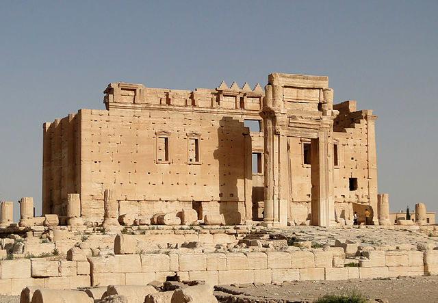
Temple of Bel (photo: Wikimedia)
Cornell assistant professor of Near Eastern Studies Lori Khatchadourian suggests the latter and she is correct, if the only motivation for the Daesh is to irritate the west. On the other hand, it appears that the destruction of the funerary towers came only into light, because archaeologists were monitoring the Palmyra area and noticed that the monuments had disappeared. This act is more likely to be a result of plundering the monuments for illicit antiquities used apparently to fund the organisation. This motive for the recent destruction has been suggested by the Lebanese-French archaeologist Joanne Farchakh. Would the suggested media silence help or hinder the work people do against the spread of illicit antiquities originating from Syria?

Temple of Bel (photo: Wikimedia)
ASOR Syrian Heritage Inititative by the The American Schools of Oriental Research has written a very sensitive report about the destruction in Palmyra, not only the destruction of monuments and loss of cultural property, but also of human loss. This report is exactly the kind of monitoring by the specialists and heritage professionals as Lori Khatchadourian is calling for during the media silence. Nevertheless, if there is a media silence, how this information will be shared among the scholars in these times of Facebook and Twitter? Would it be totally beneficial, if the real damage is only whispered among the chosen ones in the back cabinets of the UNESCO or equivalent?
The illicit trade and trafficking are to be discussed in a conference in Sofia, Bulgaria, organised by the Royal Norwegian Embassy in Sofia and the Norwegian Institute for Cultural Heritage Research with the patronage of UNESCO. The Balkans are a major route for human and immobile trafficking and working together with the Bulgarian Ministry of Culture, the Bulgarian Interior Ministry, the Embassy of the Republic of Cyprus and a Dutch non-governmental organisation called “Walk of Truth” the Norwegian partners will try to find ways to stop the trade. The key note speakers include Dr Neil Brodie, a known specialist and researcher on illicit antiquities, and Dr Rubina Raja, a known scholar of history of religions at Aarhus, Denmark, so the potential is there, partly depending who are attending the workshops and roundtables advertised. It can raise awareness among the border guards, local professionals, auction houses and private museums and collectors alike. It will facilitate and increase international collaboration as well.
The preservation of cultural heritage, the combat against trafficking, the protection of refugees and multicultural tolerance are themes that join the positive voices in different discussions on Syria and the Mediterranean ‘migration’ crisis. Tim Whitmarsh and Tom Holland wrote in the Guardian about Palmyra as a symbol of syncretism and mutual tolerance, as a monument to all the Daesh seems to stand against. These voices definitely were worth reading and hearing in the current refugee situation.
In reality, it may in occasions be that the Daesh does not really care always what the West thinks. Part of the destruction may be for internal discussion and local politics. The Wahhabi Sunni ideology against worshiping idols has been used to explain the apparent disregard the Saudi government has shown to the heritage in Mecca and Medina. The original monuments from the times of Mohammed and his family members and disciplines have been erased in order to accommodate the crowds taking part in the Hajj, the pilgrimage described as one of the pillars of Islam. Temples and art are part of idols and in the case of Palmyra definitely built by infidels. The Daesh may need to be seen as pious. Locally, in Palmyra, one can only assume that the ruins are revered as a source of pride and livelihood for the town. Demolishing the main landmarks will show to the town people who have the power. Both of the two measures may be needed in order to maintain internal cohesion and ideological rigour within the Daesh. In these discussions, western media may be just noice, even if useful noice, if it helps to track the trafficking routes and safeguard other heritage sites elsewhere. The discussions have already brought about different archive resources on Palmyra, such as the photograph collection of the French Institute in the Middle East (IFPO).
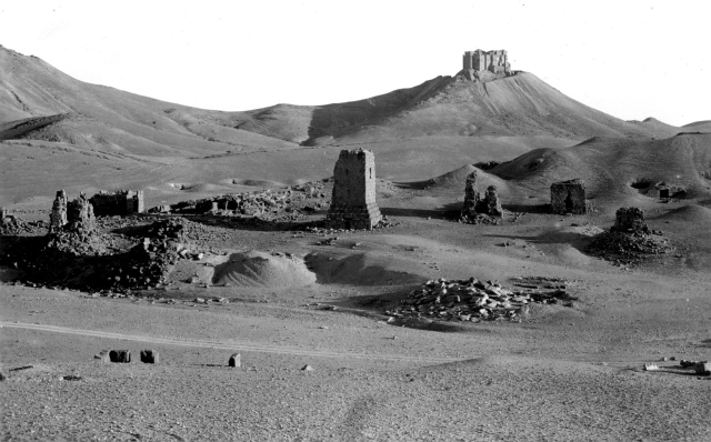
The western cemetery area in Palmyra (IFPO)
Nevertheless, considering the voices discussing the past of Palmyra as a symbol of tolerance and a source of civil pride in a lay society in Syria, one can already perhaps dream for the future. This can also be seen as part of trying to celebrate the surviving Middle Eastern heritage as Khatchadourian suggested and as Aro-Valjus has done in her blog. One can dream of peace in Syria again. A return of Syria that had 1 million Palestinian refugees. A dream of a safe return for the refugees to whose plight the world has started to answer and has started to drop the heartless rhetoric of the right at the face of human suffering and the senselessness of the war. The refugees are now called refugees in the and one day they may be able to go back. One can dream of a time when the Temple of Bel and other standing ruins made to dust in Palmyra can be rebuilt. They will not be original, but may be destruction will bring cooperation and healing to Syria. It could be an act of rebuilding the society through rebuilding the monuments that stood for tolerance and multiculturality.
I am starting to favour the Middle Eastern name, used also by the French government, for the organisation behind the Caliphate – I do not wish to call them a ‘state’ in English nor blacken the name of the Egyptian goddess. Even if ‘daesh’ includes the word ‘state’, it is not directly recognisable to a non-Arabic speaker, and even if the word allegedly sounds like ‘someone who crushes something under the foot’, it sounds also very similar to ‘someone who sows discord’ – very fittingly in so many senses. It will undoubtedly be their downfall as well.
If you can Finnish, you can watch an interview with Sanna Aro-Valjus in the Finnish breakfast TV.